D Pillar – Painting? (Post #602) 10/3/2022

D Pillar Work, Interior trim painting…allergies

I got out into the shop and was working on some peripheral projects over the weekend. Peripheral because they don’t directly get the Big White Bus back on the road for driving. These are the cosmetic fixes, plain and simple. The primary project line is getting the motor back to 100% and making it reliable. I completed the repair of the heater fan blower motor. That disabled the motor due to the coolant hoses being removed.

I did start the motor about a month ago. Surprisingly she fired right up. I was really happy about that. I have not addressed the original issue with the reliability of the motor which is the ignition system. I’m 94.67% sure I’m going to replace the distributor with a Davis Unified Ignition (DUI). Its an all in one unit built in Memphis, Tennessee. Seeing the price today makes me wish I’d have bought it a year ago. The price has gone up about 50$(US). Although waiting has allowed me to start the one year warranty when I’m actually driving her.

All other projects from the list….linked here [Okierover.com Blog] not counting the replacement alternator, which I believe is where my vampire batter drain is coming from, are not keeping me from driving her.

I’ve ordered Knightsbridge seat covers. I finally talked myself out of putting leather back in. The estimates I got from local car upholstery companies were more expensive than ordering new leather…..customized with embroidered family crests on the headrests and my face digitally embroidered on the seat backs. Just kidding, but seriously, super expensive. So I ordered seat covers I’m not afraid to get muddy and dirty.

My new radio and speakers have arrived. I’ll need to watch the install video, call tech support 16 times, and finally give up and have the Evil German Dude or JagGuy help me install it. I’ll post something about that when I get closer to installing.

Still a couple of interior trim pieces that need painting. I am not going to remove them, I’m going to paint them in place, its just not worth the effort to remove them. The door cards came out without much effort and I need to wash them down, tape them off, and paint them. Perhaps next weekend.

I know this post was about the D Pillar so let me close with that. I have the welding repair still yet to do. As mentioned in the video, I used a palm sander and 100grit sandpaper to remove the glue from the beauty cover. It formerly had vinyl wrapped on it.

I’ve cut out some closed cell neoprene foam to replace the rust inducing open cell crap they delivered the Range Rover with from the factory. I’ve decided to start with painting the beauty panels. Rattle can style…can’t get much more redneck than that. I’ll show the finished product when I get it done.

Thanks for reading, watching, and Happy Rovering.

Southwest Oklahoma Expedition – January 2021 Part 2 (Post #591) 2/2/2021

If you missed Part 1, jump over to that post and catch up (the link is after the break). Or don’t, this is still a free country, more or less, depending on who you ask. What follows is Day 2 of the Great Southwest Oklahoma Expedition! See there, this trip just got more awesome the more we drove!

Continue reading “Southwest Oklahoma Expedition – January 2021 Part 2 (Post #591) 2/2/2021”

Capulin Volcano and the Northwest Passage 2016, Part Three (Post #571) 1/23/2017

Day Three

We woke in Picture Canyon. Erik and his team planned to return to Oklahoma City. We made a big breakfast cooking everything we hadn’t eaten so far on the trip. By the time we finished cooking eating and packing up Mr. Fisher and I had to change our plans too.

The trek up Black Mesa and back takes at least 5 hours. We had 7 hours of driving to get home. We had an hour and a half to get to the trail-head. The math put us in Norman around 11 PM or even later. That wasn’t really an option as I had to go back to work on Tuesday. So we skipped Black Mesa. I’ve been to the Black Mesa area three times and I haven’t made the hike yet. My next trip to the region Black Mesa will be my primary goal. I’m doing that first.

We headed to Campo, Colorado to get some fuel. We found a garage there with a mechanic, that’s something to put in the memory bank just in case. We fueled up and struck up a conversation with a local gentleman who heard we were overlanding and gave us a great suggestion for a route home. We headed south out of Campo looking for Road C. We headed east and soon found ourselves out on the wide open grassland.

Along the way we found a historical marker and stopped to check it out. Turned out it was a short cut for the Santa Fe Trail.

Santa Fe Trail Aubry Cutoff

You can find it by clicking this map.google.com link.

GPS coordinates

“Santa Fe Trail Marker with Stone Posts”
37°01’05.7″N 102°27’42.3″W
37.018258, -102.461744


The markers were for the Aubry Cutoff. From the sign, it was a way from the Mountain Route to the Cimarron Route on the Santa Fe Trail.
The sign was well weathered and really hard to read so I translated it for you.

“Francois Xaver Aubry was born December 3, 1824 near Quebec. In 1843 at 18, he left his home and moved to St. Louis, Missouri where he began working as a clerk for a French Canadian merchant company.”
“In 1846 lured by the talk of trade making money and adventure on the Santa Fe Trail, he gave up his job as a clerk and became a full-time trader. By 1850, Aubry had traveled multiple routes with the goal of finding the shortest sand-free path that provided adequate water and wood. In 1851 he found it establishing what became known as the Aubry Cutoff.”
“From 1846 to 1854 Aubry was among the business most influential merchants on the Santa Fe Trail. His caravans were usually large and his speed and reliability in getting goods to the right market ahead of others was legendary. The average length of Aubry’s trips was 37 days while other merchants would take up to 90 days to deliver their goods to Santa Fe.”
“Along with this mercantile reputation he developed a talent for individual travel. Aubry’s 730 mile trip on horseback from Santa Fe to Independence Missouri in the **** days…”

The rest of the sign is indistinguishable.


The grassland was amazing. I’ve never been so far away from everything. It is a truly wide open place.

A panoramic view.

Such a great road.

There were other markers laying out the Santa Fe Trail.


We crossed in to Oklahoma.

Mr. Fisher stands in Colorado and Oklahoma at the same time.

We decided to head to the Washita Battlefield National Historic Site. I’ve never been but have wanted to go several times. The shortcut through Texas was really terrible. We battled the 18-wheelers hauling pre-hamburgers and pre-steaks at mach 2 on the roads throughout the panhandle of Texas. I’m pretty sure most of them should be arrested and thrown into jail for the speed they were traveling and the absolute utter disregard for other drivers. Seriously we were nearly rammed by two 18-wheelers going well over 80 mph. There’s no way they could have stopped if something happened.

We stopped in one these cattle towns and made some sandwiches and ate lunch. Every town had a silo like this one.

Cow town with a silo.

The Washita Battlefield National Historic Site is a real nice museum and was free! We stopped and watched an informative video about the event. We looked at the artifacts and read some of the interesting perspectives of the times. There would be a recollection of a white person and a recollection of a native person showing the two sides of the same event. Very informative.


We then went down the road to the actual site. The river has moved since the original event but with a little imagination you can put yourself there that fateful winter day.
We took the two lane highways home. I can tell you as we came back into civilization I actually longed for the wide open spaces of the plains. The rest of the trip was uneventful and we managed to get home without dying.

Part One.
Part Two.
Thanks for reading and Happy Rovering.

Dash Mounts (Post #568) 1/22/2017

Dashmounts

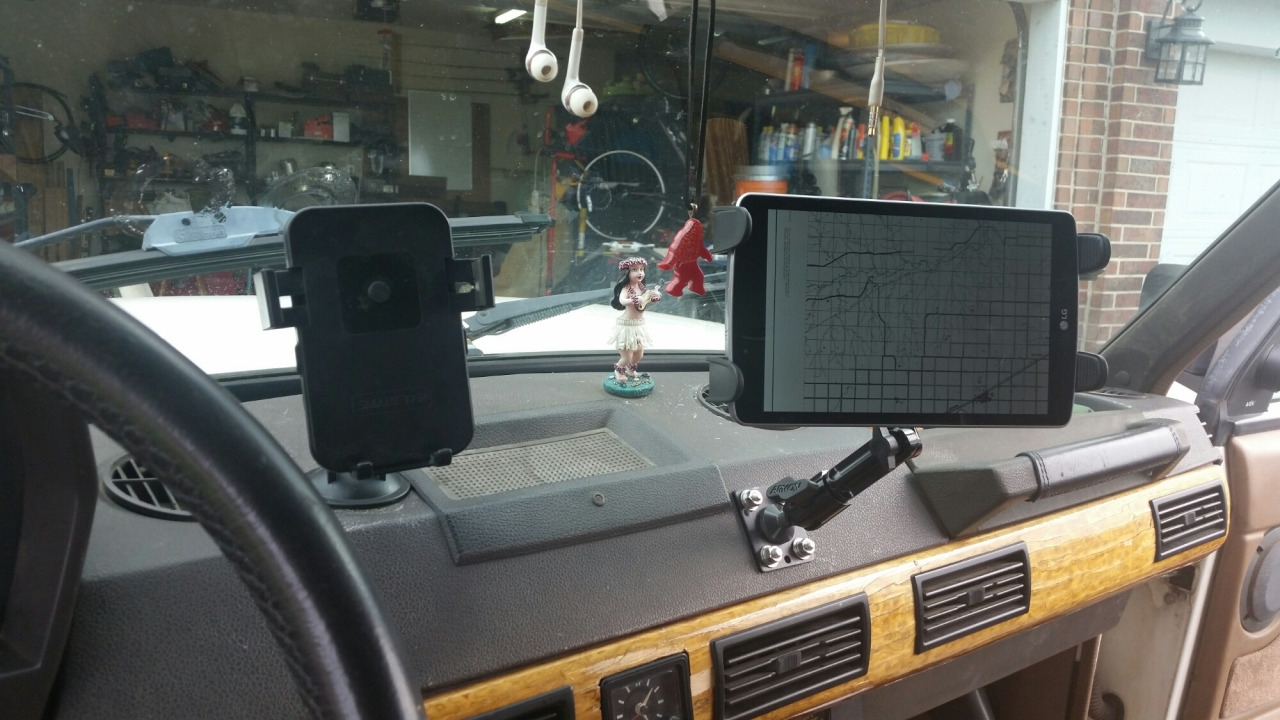
I added a mount for some tablet based navigation. I also added a mount for my phone due to the Oklahoma summers melting the suction cup windshield mounts.

Installing it was a bit of a challenge. Under the plastic dash cover which the Evil German Dude gave me quite a lashing over poking holes in it lies a metal framework. In my defense, that dash is faded, falling apart from years of Oklahoma sun, and generally not worth preserving. So the mounts are mounted through the plastic and through the metal and I assure you are quite sturdy.

I’ve had a few questions about what software I’m running on my Android tablet for offline navigation. Let me first say I’m not sure the software I’m running is the right application for me. We had some issues using it when we were in New Mexico and it turned out that using our phones connected to the interwebs was more convenient. Mostly because I wasn’t familiar enough with the software to tell Mr. Fisher how to use it and my impatience with my A-driver/navigator response time being too long when I need to know the next turn. Thankfully Mr. Fisher was very understanding and forgiving of me.

The software is MapFactor: GPS Navigation (Play Store link) its available free from the Google Play Store. You can also download areas from Google Maps for “offline use”.

Thanks for reading and Happy Rovering.

Capulin Volcano and the Northwest Passage 2016, Part Two (Post #565) 1/19/2017

Day Two

This is part two of the Capulin Volcano Northwest Passage. We went to meet Fall and were not disappointed. She was in full force on the Volcano with a North wind putting a chill on things.

Warning this is a huge post with tons of pictures.

We drove to the Volcano. We stopped and took the obligatory picture with the National Park sign for Capulin Volcano. We headed on to the visitor center and paid the admission fee to the cute Park Ranger. We then drove to the parking lot near the top.

We hiked to the top. You can see a mountain range in Colorado and Black Mesa from the top. There are well marked signs that explain the lay of the land. We were woefully unready for the active Cougar area. It was a relief to find out they were warning us about the big cats and not 60 plus year old women.

We left the volcano and headed to Folsom, New Mexico. We stopped for some pictures at the Folsom Hotel and felt the call of the old west in the sleepy little town. A picture in the hotel window alerted us to the fact the Hole in the Wall Gang once frequented the area.

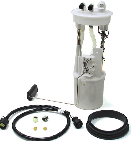
We headed toward Des Moines, New Mexico to pick up our gravel road to the state intersection. I feel like now is a good point to caution you about the availability of gasoline in these remote towns. We knew there would be few options and keeping a full tank was a priority. We even brought extra Gerry cans and filled them when we thought the chance to fill up might be in doubt. If you are planning this trip keep in mind how many miles you have planned to drive. It wouldn’t be a bad idea to know what kind of range you can get on a tank of fuel when you are driving 20-40 miles per hour. This is where I learned the fuel gauge on the BWB is not very indicative of the amount of fuel in the tank. It is weighted a little heavily toward the lower end. That will need to be investigated again.

We stopped for a pit stop in Des Moines and then out on to the plain to see what we could see. What we learned about electronic maps and how they are incredibly incorrect. There were several times where a road was named wrong or didn’t even exist.

Erik remembered there was a more scenic route and we made our way to find it. Turned out to be a very beautiful canyon to drive through. The roads were labelled like highways but were made of gravel. The driving was not technical. If it had rained the night before it might have been much more challenging.


We made Oklahoma and turned toward the corner of the state’s monument. We found it up the road from the Black Mesa trail-head. We hung out a while and took pictures. We also planned our next stop. In lieu of Black Mesa State Park we opted for Picture Canyon in Colorado. I’m so glad we did.


We left out of the Black Mesa area turned North at the “dinosaur bone” and headed toward Picture Canyon. On the way we stopped to see a rather large tarantula. He became very friendly and crawled up the leg of one of Erik’s friends. Whole lotta NO in that for me.

We also turned back to see where another apparent overlander had taken an unmarked trail. By the time we got back to him he was already headed back to the road. He said there was nothing to see up there except a windmill. I didn’t want to seem like we were following him or wanted him to feel uncomfortable so we kept it short and went in different directions.

If there hadn’t been signs telling us there was a canyon we may have never found it. It is literally a canyon in the middle of the Comanche National Grassland. You drive on rolling hills and out of nowhere there’s a canyon.


Panoramic view of the top
A panoramic view above the canyon.
We then took the hiking trail around the inside of the canyon. The history is awesome with several petroglyphs and an abandoned settlement. Pre-historic man used the canyon probably as a kill site for the millions of herd animals. They also most likely lived there. In the early 1900’s settlers tried to make a go of it by living in the canyon. Their rock house and most likely barn are still visible.

There are also caves. The caves are now caged off. The bats in the area are struggling to survive. The white-nosed fungus is basically Ebola for bats and scientist are trying to figure out what the cause is. Humans are one of the first culprits thus the cages at the entrances to caves throughout America.

We saw all the petroglyphs listed on the displays at the trailhead. It was a nice walk. We returned to camp and started dinner (seasoned chicken tenders, potatoes, rolls with honey butter). We ate and had some beers waiting for the big show. The big show was a completely dark sky with no light pollution. We could see the Milky Way and a bazillion stars. The meteor shower did not disappoint as well. We saw so many satellites we stopped even mentioning them.

We settled in for some much needed sleep after a long day on the trail.

I hope you enjoyed the galleries and I’ll post up the third day soon. Thanks for the retweets and forwarding the post.

Capulin Volcano Part One Here

Capulin Volcano Part Three Here

Thanks for reading and Happy Rovering